


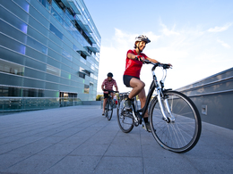
Mit dem Rad entlang der LILO nach Linz


Interactive elevation profile
Create PDF
Tour-Details
Starting place: 4722 Peuerbach
Destination: 4010 Linz
duration: 3h 0m
length: 52,0 km
Altitude difference (uphill): 370m
Lowest point: 260m
Highest point: 389m
powered by TOURDATA | Suggest a change
Cycling along rivers is widely known and popular. Why not follow the course of a railway line, we asked ourselves. Said it. Done. We took the Linz local railway to Peuerbach and cycled back to Linz on little-known paths and side roads.
You should start this cycle tour by immersing yourself in the world of the stars at the Kometor in Peuerbach. The celestial body designed by the artist couple Hebenstreit seems to float above the castle park and with its two levels of experience, it is a tribute to the astronomer Georg von Peuerbach. The cycle route initially leads along rivers again and the railway also follows the course of these until Prambachkirchen. You pass Bad Weinberg and soon branch off onto the lonely route up to Wackersbach. The last hilly foothills of the northern Hausruckviertel can be found here around the Kirnberg. The route then descends into the flat Eferding basin and along side roads you reach Hartheim Castle. The beautiful courtyard and the memorial are a good reason for a break. From Straßham there are a few more climbs to overcome before you roll through Rufling and Leonding towards the railway station in Linz.
Route:
Past Peuerbach railway station, turn left before the LILO railway tracks, along the Aschach to Waizenkirchen, towards Aschachtal to Schurrer-Prambach, turn right along the Prambach to and through Prambachkirchen, Bad Weinberg, turn off at Mittergallsbach-Obergallsbach to Wackersbach, down to the B 134, 100 metres to the left, Güterweg Ranzing to Fraham, on the Naturfreundeweg to Emling, Hartheim and Straßham, on the road towards Leonding, turn off to the Kirchberg-Thürnau stop, gravel path to Thurnharting, via Rufling, Leonding and Gaumberg to Linz.
Characteristics:
Entertaining cycle tour for explorers, mostly on side roads, two short sections on gravel, the route is easy to find with the help of a more precise road map or the GPS track
Refreshments:
Inns along the route
Map:
Kompass Digital Map Upper Austria
Internet:
www.linzer-lokalbahn.at
www.kometor.at
www.schloss-hartheim.at
Book tip:
Neuweg/Peham: Genuss-Biken in Oberösterreich, OÖNachrichten Edition by Trauner Verlag, Linz 2010
Most economical season
- Spring
- Summer
- Autumn
Please get in touch for more information.
Phone +43 732 7070 - 200
E-Mail tourist.info@linz.at
Web www.linztourismus.at
http://www.linztourismus.at
Interactive elevation profile
Create PDF
Tour-Details
Starting place: 4722 Peuerbach
Destination: 4010 Linz
duration: 3h 0m
length: 52,0 km
Altitude difference (uphill): 370m
Lowest point: 260m
Highest point: 389m
powered by TOURDATA | Suggest a change
Suggest changes
Please let us know how we can improve the quality of this object or if there is any incorrect information on this page (eg. opening hours, contact, etc.).
Please fill in all fields marked *.